| The origin of this article is a correspondent to the Hull Daily Mail in 1974, and, seemingly, little else. In 2003 BBC Radio Humberside suggested an elaborate rapid transit rail scheme to solve traffic congestion, considerably worse than it was in 1974 and 1975, especially with side streets full of 20 mph bumps and one way directions, and new filter traffic lights causing queues at main junctions. |
| This article, verbatim: Buckley, J. (1975), 'Light Rapid Transport for Hull', Planning Report, Modern Tramway and Rapid Transit Review, Vol 38, No. 452, August 1975, Ian Allen, 258-261. |
| Planning Report | R. J. BUCKLEY |
THE major Centre in the newly formed County of Humberside is Kingston-upon-Hull, more usually known as Hull, and with a population of about 280,000. Local transport, which has varied in the past from horse wagonnettes, through horse, steam and electric trains, to trolley-buses, is now the monopoly of the motor bus, there not even being any suburban rail stations remaining in the city. Corporation Transport Department statistics show a steady decline in passengers from a peak of 102 million in 1949 to only 44.5 million today, almost exactly the same number as were carried as early as 1913. Over 3 million passengers per annum have been lost since 1956. Unfortunately this has not meant a parallel reduction in mileage, which has not changed very much for 40 years; so even the successful introduction of one-man operation has not erased the Department's operating loss (1)
Against this background, it is suggested that light rapid transit, properly integrated with the existing bus system, could provide a better service on certain intensively used routes and might thus arrest or even reverse the present catastrophic decline in passengers. One place where this has happened already is Amsterdam, where tram route 1 to Osdorp recorded a 40 per cent increase in traffic after the introduction of reserved lanes. It is not suggested that such a system would be likely to make a profit, but, if social and environmental considerations are included in the equation as well as purely economic ones, as they should be, light rapid transit becomes a very attractive proposition. That this is not merely wishful thinking is confirmed by the very stringent economic analysis to which the Tyneside Rapid Transit plan was subjected before approval by the Department of the Environment (2)
Without excluding the possibility of development elsewhere, attention is con-centrated on a scheme for linking Hull and the still-dcveloping satellite town of Bransholme, which is eventually to house 55,500 people, nearly one fifth of the city's population. Bransholme is about 6 miles from the city centre, and is served at present by seven all-day bus routes, giving a frequency of 12-13 buses per hour off peak, and offering about 1000 seats between them. Buses use three alternative means of access to the estate, via Holderness, Beverley and Stoneferry Roads.
Some years ago the Hull - Hornsea rail branch was closed, and this has meant the lifting of the Low Level line within the city, goods traffic to the docks being concentrated on the crossing-free High Level line. The official plan for this valuable right-of-way is that it should become an intermediate ring road, connecting with the new docks road on the Humber bank. More recently, however, two local railmen have suggested reopening part of the old railway to passengers, offering a 40-minute service to Bransholme residents between Sutton and Hull, with intermediate halts at Tweendykes and Chamberlain Road. As a matter of fact the two plans are not incompatible, as the proposal is to run trains via the High Level line as far as Stoneferry, only diverting on to the former Hornsea branch. A reduction in journey time and in traffic congestion, as well as a saving on the cost of fuel and of new buses, are amongst the advantages claimed for the rail scheme. The ring road, of course, is also expected to reduce traffic congestion by taking heavy lorry traffic out of the city centre.
Both of these plans, however, have grave disadvantages, and a third alternative, light rapid transit, has much to commend it. The major drawback to urban road schemes was succinctly put by the Chairman of London Transport when he said that traffic conforms to Parkinson's law and expands to fill the space available (3). The proposal to reopen a part of the railway to Sutton would, however, be of no more benefit in public transport terms. There would be little or no improvement in journey times because of the circuitous route via the High Level line and the necessity for changing from train to bus at Sutton. Probably very few people would use the line anyway, since a survey by Selnec has shown that passcngers need to save at least 10 minutes on a journey to be induced to change vehicles. The suggested service frequency is too low for urban conditions as well, and could not be easily increased on a rail line heavily used by goods trains. Most of these objections could be obviated by a light railway service along the former Low Level line extended at its outer end into Bransholme itself. Such a line would also provide more scope for intermediate traffic, a point made by a newspaper correspondent when he said:
...stations to serve different areas in Hull could save a lot of unnecessary traffic congestion in the city centre... perhaps a tramway could he evolved out of the disused lines around the city" (4).
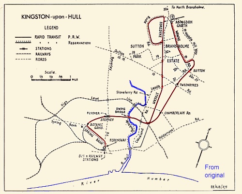
Taking the Low Level line trackbed as a starting point, the following route is suggested for a light rapid transit line between Hull and Bransholme. Almost all public transport in Hull is centralised at the bus and rail stations off Ferensway, and the rapid tramway would have to start here, either in the bus station itself or at a new terminus built on spare land beside the railway station. The opportunity might well he taken to reconstruct the bus station itself, which is hadly in need of modernisation. Ideally the light railcars would then proceed over BR tracks as far as Botanic Sheds, crossing Springbank by a flyover. However, it is not likely that running powers would be granted, and instead the tracks would have to he laid in the street along Ferensway and Springbank. Both streets are wide, except for a small length of Springbank which will presumably be widened when old property is demolished, and the tracks could probably be segregated by Amsterdam-style "yellow-ridge" reservations with pedestrian refuges. If buses also used these reserved lanes, as they do in Dutch cities, the general traffie flow would he improved. Some short-distance passengers could be expected along Springbank as well, since the area is mainly residential.
At the former Botanic level crossing and station the tracks would swing to the right on to the Low Level line itself, with a halt at this point to serve Princes Avenue. At the former Stepney station the light rail tracks would cross Beverley Road by a flyover, and there would be a halt here too. The next level crossing was over Bankside, and this would probably have to be reinstated and a halt provided in this industrial area to replace Wilmington station. The most difficult obstacle on the proposed route is the river Hull, which is heavily used by shipping and cannot therefore be crossed by an ordinary bridge. BR trains used a swing bridge, similar to those on all the other river crossings, and incredibly enough it is not only still there, but manned and swung daily purely for pedestrian use, which must make it about the most expensive footbridge in the world! The simplest solution, then, would be to run the new tracks over the existing bridge. If it was felt that manning it would be too expensive, the only alternative would be a tunnel costing about £4 million, since a flyover would not clear shipping at all states of the tide. From the river the light railway would cross Stoneferry Road by an overbridge - unfortunately the old one has just been demolished - and then go under the BR lines on the High Level embankment. There would be a halt here to serve James Reckitt Avenue.
At this point the old railway line used to cross an agricultural drain known as the Foredyke Stream. This has now been filled in, and provides a direct route to Bransholme. It is suggested, therefore, that there should be a junction here with one route following the drain and the other the railway, The latter would run to Sutton via Chamberlain Road and Tweendykes, with a halt and a light protected crossing at both these points. Instead of terminating at Sutton, as in the rail scheme, the tram tracks would continue along the trackbed for about a half mile, swing left past the bottom of a new housing development over fields, and strike Bransholme itself on Noddle Hill Way. Still turning left, single tracks would be run along reservation along either side of the road up to and along the spine road of the estate, Wawne Road, to terminate at Abingdon Garth. This route could later be extended into North Bransholme, which is to house 15,000 people on top of South Bransholme's 30,500. The other fork along the drain presents more difficulties as there is a large number of road crossings, some of them built only since the drain was filled in. Where drain bridges exist - at Chamberlain, Leads, Sutton, Holwell and Bude Roads - the tramway might dive under the road in a shallow cutting. In the case of other minor estate roads, unprotected level crossings would suffice. In order to be able to serve more of Bransholme, this branch would end in a large loop right around Bude Road.
These lines would provide a rapid tramway service to a large part of Bransholme, giving residents access not only to the city eentre, but also to industrial areas in Stoneferry, and to Beverley Road and Springbank. Intermediate traffic from these areas to Hull could also be expected. Buses from Bransholme would still be needed for people wanting to travel along Beverley or Ho!derness Roads and for people living over a half mile from the tramway. These needs could be met by the retention of two of the existing seven services - No 19 via Noddle Hill Way, Sutton Park and Beverley Road, and No 32A from Wawne via North Bransholme (site of) and Holderness Road. Integration between buses and tramway could be facilitated by allowing free interchange between the two modes of transport where they cross in Bransholme itself.
The distance via this route to the outskirts of Sutton/ Bransholme is about 4.5 miles, and to either terminus about 6 miles. Assuming the cars run at an average speed of 18 miles/ hour including stops, parts of Bransholme could be reached in only 15 minutes, and the whole journey accomplished in 20 minutes. Hull buses have an average service speed of 13 miles/ hour including stops. Services via Stoneferry probably run at above average speeds, as there are few houses in this area, and they too accomplish the journey in 20 minutes. Other routes take longer though, and even where this is not the ease a segregated light railway has the advantage of constant times as between off peak and peak periods.
As to costs, running costs are likely to be lower for a light railway than for buses, particularly in days of rising oil prices. Capital costs would be heavy, but would be partly offset by lower running costs and also by less easily quantifiable factors sueh as reduced traffic congestion, improved reliability, etc. In the Tyneside study it was calculated that rapid transit would produce an appreciable operating benefit from lower costs and higher revenue as compared with an all-bus system, and on top of this there would he even larger measurable economic benefits - up to Ł5 million in this case - quite apart from non-measureable benefits in environmental factors.
To sum up then, a light rapid transit line between Hull and Bransholme is both possible and desirable. It is possible because Bransholme provides a large high-density population with well-defined transport needs, needs which can be met by providing a fast, reliable and comfortable service on its own tracks it would contribute to the relief of traffic congestion, whilst at the same time actually attracting passengers back to public transport. The conclusion drqwn by the authors of the Tyne - Wear Transport Plan for the 1980's is an apposite one...
...we believe that the only way to provide the level of service and accessibility required in the future, in the face of increasing road traffic, is by significant investment in a system with its own exclusive right of way (6).
In addition to the acknowledgements given below, I should also like to acknowledge the help given by Mr Relton, the League Planning Officer, in the preparation of this article, particularly in the matter of costing the scheme.
This article: Buckley, J. (1975), 'Light Rapid Transport for Hull', Planning Report, Modern Tramway and Rapid Transit Review, Vol 38, No. 452, August 1975, Ian Allen, 258-261.