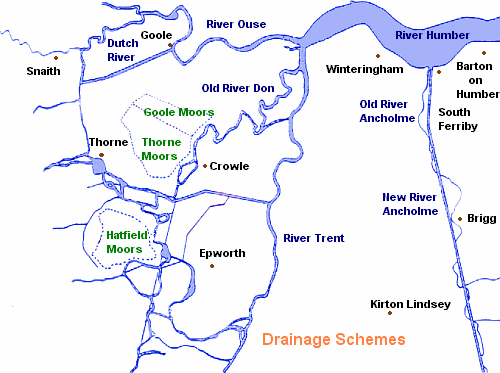
Up until the seventeenth century, much the land surrounding the Humber was often flooded and constituted ings, marsh and fen, with only a few areas reclaimed with limited success. This was a landscape where ordinary people could live by fishing, fowling and reed cutting. This was particularly the case further west at the Isle of Axholme.
Charles I obtained the services of the Dutchman Sir Cornelius Vermuyden to drain Hatfield Chase (the King's estate) and the Isle of Axholme. A canal called the Dutch River had to be built to make the changes work. It was an expensive project when done. The idea was that the King, Vermuyden and the people would each receive one third of the resultant drained land. As a result Dutch and French people were able to settle in Sandtoft now owned by Vermuyden and his backers, the local people being removed.
Of course the people who had lived there weren't too happy about the carve up that took place. Having fled persecution, the foreigners were driven out by the locals. Their homes and crops were destroyed, and their church became a stable.
Near South Ferriby and directly south in 1638 the straight River Ancholme was made and had the same effect on the locals. They took back their land and because they attacked the drainage works the system did not work until it was able to after the land was closed as part of the Enclosure Acts in the 1700s.
Embanking was one reclamation method used. The sea level was lower from the mediaeval period which saw the notorious sand banks of the Humber become further exposed. Land was able to be reclaimed because the salt leeched away and so grass grew. Sunk Island east of Hull was gained. Reed Island above the Ancholme is actually an island. In many reclaimed areas farms were developed.
Source:
Humberside County Council Archaeology Unit (1987), Tudor and Stuart Humberside (1485-1714), Booklet 9, Humberside County Council Archaeology Unit/ Manpower Services Commission, pp. 26-28.