|
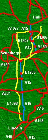
The A15 is in roughly three sections, and this account is of the road going south on two from the Humber to Lincoln.
|
|
It starts on the outskirts of Hull as a dual carriageway, and connects from roads west, north and east, though to come from Hull on the A63 requires quite a deviation under the high Humber Bridge and over half a mile beyond to come off the A63, to then cross over the A63, and continue to rise up over half a mile backwards back to the bridge roundabout to then go over the A63 again to the bridge.
|
|
|
The Humber Bridge is its own entity. After a settlement with the government in 1997 the users continue to pay massive tolls and the bridge doesn't go bust quite as quickly. The tolls maintain higher prices in the shops and some of the cheapest houses in Britain on the southern side of the Humber.
|
|
The weather is usually worse on the bridge than anywhere else. However, the wind is remarkably steady until getting to the road going from the bridge on the south bank downwards, where it can throw vehicles around in an unsteady fashion. If anyone breaks down on the Humber Bridge (as they do), cameras spot the vehicle and the Humber Bridge Board rescues it free of charge and leaves it by the roadside at a point where other rescue services can collect it.
|
|
The Humber Bridge Board knows two speed limits, 50 mph and an advisory 30 mph in difficult conditions. Few take any notice of the lower limit, except motorcycles leaning into the wind. It is never 40 mph. Sometimes the wind is up and down the bridge and doesn't matter, sometimes it is across the bridge and then it does. Going under the towers the wind goes the other way and vehicles veer sideways. Substantial road works mean the Board covers the main signs and clip over repeater signs with ones saying 30 mph, which is then compulsory. The bridge stays open almost always, but sometimes high sided vehicles either have to go around the Humber and cross at the Ouse or wait (in Barton, presumably).
|
|
Just off the high roundabout in a southerly direction, on the road to Scunthorpe, there are two long laybys. They are always mysteriously full of cars and people pass and wonder what on earth are they all doing there. The answer is that in the morning a lot of cars arrive. People then get out of some and leave them, and a few of them set off to cross the bridge. It is simply because the tolls are so high that car sharing takes place into Hull. It costs nearly £5 for a return trip.
|
|
People can also get the coach to London on this roundabout near Barton. The coach to stop has to be booked and then the person stands on the roundabout. The coach instead of going under the roundabout comes up it and collects the person waiting. However, the scheduled hourly service to Humberside Airport, Grimsby and Sheffield (the coach connects at the airport - it used to do this at a cafe but the owner wanted more money) does not come up to the roundabout to collect people from Barton. They have to use the train, which itself has a bus connection from Hull, the one that replaced the ferry into New Holland.
|
|
The A15 has come down from the Humber Bridge and rises up and yet underneath the roundabout as it goes into the chalk hills of the Lincolnshire Wolds. These wolds have swept well under the river and alluvial soil and sweep up again. There is a chalk cutting south of this roundabout and still rising. In fact the road rises quite further as it rides on top of the wolds.
|
|
It is a dual carriageway from the Humber Bridge all the way to the M180. It is grade separated throughout, with a narrow strip and what is effectively a soft hard shoulder.
|
|
The next junction after the one to Barton is one to Brigg, the B1206, that is via the old road. It is also a junction for heavy lorries to double back to New Holland, avoiding Barton. There is a road to the centre of Barton too. It would have been a junction for the industrial area on the eastern side of Barton too (the road to New Holland so far) but it failed a public enquiry. The road appeared for a while on the A-Z road atlas and they then had to remove it.
|
|
The next junction south goes nowhere. It is to two cul de sacs to some business spaces and underneath the dual carriageway is a narrow bridge connecting the two cul de sacs with traffic lights. They obviously saved money there.
|
|
Then comes the long hill down towards the A180 and M180. To the east is the noisiest road in Britain, a concrete monster with dangerous (still) laybys (which were made safer a few years ago). The A15 stops here, it is the A18 which continues opposite, forming in one direction the back door way into Grimsby (since the A180 was built) and to the west is Brigg. To continue on the A15 the driver needs to go on the Motorway (or through Brigg, if learning).
|
|
At one time drivers on the A15 to Lincoln had to go through Brigg. It took them through villages to the Roman Road, Ermine Street. In fact Ermine Street did continue up to the Humber, but there was a gap with no more than a track up it (and I think it was gated). With the opening of the M180 that gap was filled with more of the straight road.
|
|
So it is possible to come from the Humber, except that to discourage this the road in the adjacent village north of the M180, Broughton, has speed restrictions and physical road narrowings.
|
|
The A15 road south from the M180 is not counted by the AA as one of the most dangerous roads in Britain, but it ought to be. The new part has good sight lines, but it is still single carriageway and is seen as a necessary moment to overtake anything that can slow the journey in front. Speeds tend to be well above the national limit as it is straight and most have come off the motorway.
|
|
However, after the A15 passes where the old A15 appeared, now a junction, the A15 weaves its wicked magic. A lorry will slow everyone down. The road is considerably narrower than it should be. Then, more and more as the road goes south, comes the hills so there are plenty of hidden dips and blind summits. There is another aspect to this A15 that people do not realise. It isn't actually straight. It does not have bends as such, except fifth gear ones at dips, but also there is a kind of sway to parts of the road. This means that a car can come off if it isn't steered at all.
|
|
There are also quite a few side junctions and plenty of people dodging across, including the odd tractor. Generally though the tailbacks on the road mean that there are big gaps for people to get across. Roads go off to Kirton-in-Lindsey and then one goes south of it on a fast route to Gainsboroough. Incidentally there is an older parallel road that comes from near Scunthorpe and goes through Kirton-in-Lindsey on the top of the chalk. The Romans had to be different.
|
|
The road goes through Spittal in the Street, where there is one of those cameras to check nothing is going wrong but which can be used for anything. One or two are speed cameras on the A15. The name of the hamlet does not come from locals' unhygienic habits but the site of an ancient hospital.
|
|
Caenby Corner roundabout, at the A631 (which is counted in part by the AA as one of the most dangerous roads in Britain), gets busy not just from traffic to the coast from the Midlands but a nearby antiques etc. market on an old RAF base.
|
|
The A15 continues south in its dangerous narrow way until it sweeps past the once RAF Scampton. Something may happen to this base, or the road may be put straight again.
|
|
After this a 50 mph limit is imposed, and the cathedral at Lincoln is spotted small and starts to get bigger. There are speed cameras and police often do some speed checks. The road continues going up and down, and passes a site where there is an annual caravans convention. When it is on the whole road is a delight, with long tailbacks of traffic and cars darting out to see if they can get into one of the long gaps with no vehicles (at least up to the next tailback).
|
|
Finally the road comes to the outskirts of Lincoln and the partly single road, partly dual carriageway bypass. This bypass was one done on the cheap, with lots of roundabouts. To get to the other A15 drivers have to touch the urban area of Lincoln as the bypass takes users from Skegness, Grimsby and the Humber Bridge to the A46, another single carriageway Roman Road to the A1.
|
|
The A15 to Lincoln is a disaster. It is narrow, undulating, dangerous, and full of tailbacks of traffic that does not mix. It encourages idiots and more sensible people to drive like idiots. It is the perfect example of the inability of Lincolnshire County Council (before and after the very different Humberside) and the government to invest in local and national roads. For some reason Lincolnshire and Norfolk have had an investment bypass in decent roads.
|
|
The A15 (and the A46) needs to be a dual carriageway. They need to build one of the carriageways and then redo the present road into the other, and in places have it as a service road. There is plenty of land (some of it growing genetically modified crops) and bridges across could lead to spacious junctions. It could be a swift road from Hull to Lincoln whereas instead there is one swift dual A15, underused because of enormous bridge tolls, and then another, much busier, which is a danger and a pain.
|