The North Atlantic Drift
and British Weather
in the World's Movements
Anyone who comes from the continent, especially Russia, to live in Britain, experiences a huge change in environment. The weather changes from a high range of difference between winter and summer temperatures on the continent to a small range of difference here, and although Britain is not as cold, its cold is more wet and can feel colder than it is. Snow is much less common, or falls in rapid bursts to clear again (more so in the east, like New Holland, which is dryer and coastal; it falls less in the extreme west which is coastal and milder). The summers seem disappointing (milder still in the coastal areas). This is how the world weather affects Britain.
The sun over the equator heats the equator more directly and over a shorter area, but not only does it cover a larger area as the curvature becomes greater, but it also heats up more particles in the atmosphere. So the equator heats much more than areas where the sun has more land surface to heat, more particles blocking it.
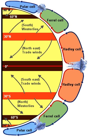
Air circulates in the world in roughly 30º blocks. The air at the equator is the most hot and rises. It then cools, moves outwards and falls back at about 30º. Most air returns to the equator as comparatively cool air but some will go outwards to about 60º as comparatively warm air where it meats colder air coming in the opposite direction and both rise up. Most air on rising up will go back towards 30º but some may go north where it drops down at 90º where as cold air it returns as lower level wind. These movements of rising and falling are in relatively stable self-circulating cells. The areas of rising air, cooling as it rises, leads to moisture reaching the dew point, condensing and then falling as rain. The prevailing westerly and easterly tilted winds on the surface which result come from the additional effect of the rotation of the earth.
|
|
The red strips represent high pressure. The black strips are low pressure. The rain falls where the air rises. The orange cells are the warmest. The green cells are midway in temperature. The blue cells are coldest. The air is also thinner towards the poles. These cells, remember, wrap around the globe.
|
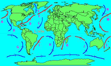
Ocean currents are movements of the water on the surface and are driven by prevailing winds. These winds mean than currents in the northern hemisphere moves in a clockwise direction, warm south-westerly, and cold north-easterly, which with the wind mean consequent warming and cooling effects on the coastlines. In the equator the movement is anti-clockwise, where warm currents are north easterly and cool currents are south westerly, again with consequent effects on coastlines. Thus the western Australian coast is cooler than would be the case from its position, but the eastern coast is warmer. Britain and Norway are warmed by the North Atlantic Drift (often wrongly called the Gulf Stream, which is further south and west).
|
|
- A, North Pacific; B, Californian; M, Kuro Siwo; N, Kurile
- C, Canaries; D, Gulf Stream; E, North Atlantic Drift; F, Labrador
- G, Peruvian; L, East Australian
- H, Benguela; I, Brazilian
- J, West Australian; K, Agulhas
|
For each ocean there is a circular motion. The prevailing winds move from high pressure to low pressure on the surface and the currents follow, the rotation of the earth creating a circular movement about the surface around the oceans. The prevailing winds involve land masses of course.
|
Warmer currents and winds bring rain, and cooler currents and winds are dryer. Warm sea currents in effect moderate climate in winter and summer from the extremes, as land is heated more in summer and the air is cooled comparatively, but create more rain, whereas sea takes longer to heat and cool, and cool sea currents make a climate more extreme, and dryer.
However, Britain is also situated where some cold air comes down from the polar region. There is a lot of mixing. The prevailing current (and wind) however is the North Atlantic Drift which brings warm moist air which moderates the British climate. When warm air rises, as it does against rising land (eg the Pennines), or hotter land (in summer), or against other opposite cooler air (from the continent or down the North Sea), the air takes the moisture it contains to high levels where the air cools. The moisture cannot be held, and the dew point is where it becomes saturated. Then condensation takes place as the air continues to rise, forming clouds. Then any further rising and cooling causes precipitation of rain, hail, sleet or snow.
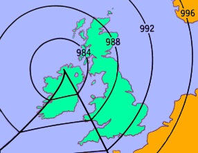
The local conditions to Britain are the formations of fronts around depressions/ cyclones. They develop mainly over the Atlantic where colder (and dryer) polar air is met.
|
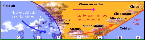
This is an approaching depression just reaching Ireland and the South West of Britain. The movement is to the east. At each front lines of equal pressure kink. The first kink demonstrates the warm front, and the trailing demonstrates forms the cold front. The air flow is anti-clockwise but the triangular sector is also how the warmer air funnels to the point of lowest pressure where it rises up the most. Fronts weaken the further out they are from the centre of the depression. The fronts are the places where warm air rises up at the leading front and cold air is sucked in at the trailing front (see below). As the front passes temperature rises. When the second front passes, temperature falls back again. Should the depression form much further north, then the airflow is convex and high pressure dominates with obviously dryer conditions.
|
Because the warmer air coming from the south west is lighter as a block, and the polar air is heavier as a block, they do not mix but form an edge. This is why there are fronts. The warm front is more or less at a straight angle from the ground, which is why high cirrus cloud is the first indication of coming, but passing, warmer wetter conditions. Wind speed increases (this until the warm front passes). The cloud thickens and gets lower, and does so until the rain falls. This is where the warmer moist air has risen as high as the precipitation level. The rain actually stops as the cloud continues and gets lower, because it is moist and waiting to rain ahead! When the cold front passes, the high stacked trailing cloud has cold air pushing under it causing a lot of air movements. The colder air swings in from the north west and downwards too causing still further rain, until the windspeeds decrease and the rain stops. But all the time there is warm air coming from the south west and new depressions follow.
|
|
- A: Cirrus cloud is seen very high
- B: Cirro-stratus cloud follows, which is lower and Alto-stratus cloud is thicker and lower still
- C: the rain is quite long and steady at this point due to the long angle of the front and the rising air and precipiation
- D: Once this has passed Stratus cloud may give up some water but only in the form of drizzle and it is quite warm
- E: Suddenly it goes cold and heavy rain with possible hail drops accompanied by thunder (because of the rapid air movements with warm air rising rapidly from cold air rushing in underneath)
- F: The trailing weather is cold and wet
- G: However the greater predominance of colder dryer air reduces the showers
|
For an anticyclone to develop, warm air has to be descending (high pressure), and once it does it tends to hold its ground. Few clouds can develop because moisture is being held. If there are any, winds will be gentle and clockwise. In summer, the land heats holding all moisture, but clear skies mean the heat can escape. If the land cools quickly moisture can form as dew and mist - this is more prevailant in early autumn and late spring when the nights are longer and heat loss is more dramatic. In winter such dew will become frost and fog. The sun was lower (so the land heats but not so much) but the nights are longer, and the cold is more intense at night. If fog and frost do form, they take longer to shift with the following low sun. In winter, high pressures forming north or west of Britain can create cold still conditions, whereas high pressure to the south or east creates strangely warm conditions. However, conditions are generally warmer in winter with a series of cyclones/ depressions. To have a change from a period of cold high pressure to low pressure depressions can bring snow. A high pressure period may simply be measured as a convex curve of isobars ahead of a coming depression.
Adrian Worsfold